|
Port
spin: "Avoiding Wetlands"
The
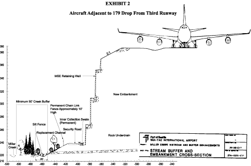
maps submitted to the Corps of Engineers to support their
wetlands permit contains a nice example of Port spin. The
Great Wall of Sea-Tac is labeled "MSE Retaining Wall
Used to Avoid Wetlands and Miller Creek".
The
photos below are of Miller Creek just beneath the proposed
wall and of a wetland 25' away from the first photo at the
base of the wall. (See the red dot on the map). The red
stake on the wetland photo marks the location of the wall.
We are sure that they can build a 120+' high rammed-earth
wall while carefully "avoiding" the wetlands and
the creek at its base. They are just going to tippy-toe
on little CAT feet all around those delicate wetlands that
nature took thousands of years to create. Sure they are…
|